Most South Coast trips stop at the same few places: Seljalandsfoss, Skógafoss, Reynisfjara and Jökulsárlón. A short detour from the Ring Road takes you to quieter waterfalls, caves, a canyon and a smaller glacier lagoon that many day tours skip. Here are nine South Iceland secret locations, listed from west to east, with how to find them and what to expect.
Why look beyond the famous stops
The South Coast is the most visited part of Iceland. It is easy to reach from Reykjavík, the sights sit close to the Ring Road, and you can fit waterfalls, black beaches, glaciers and small villages into one trip. You would think there was nothing left to find. But most visitors travel on fixed schedules and stop only where the bus stops, so a surprising number of places a few minutes off the main road stay quiet.
The big South Coast sights are famous for good reason, but in summer they can be busy from mid-morning to late afternoon. The places below are close to the main road and to the well-known stops, so you can add one or two without changing your plan much.
They are not truly secret any more, and several now have paid parking. They are still far calmer than the headline stops, and they show a side of the South Coast that many visitors miss. If you like this kind of detour, see also our secret locations of the Golden Circle.
1. Gljúfrabúi waterfall
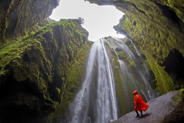
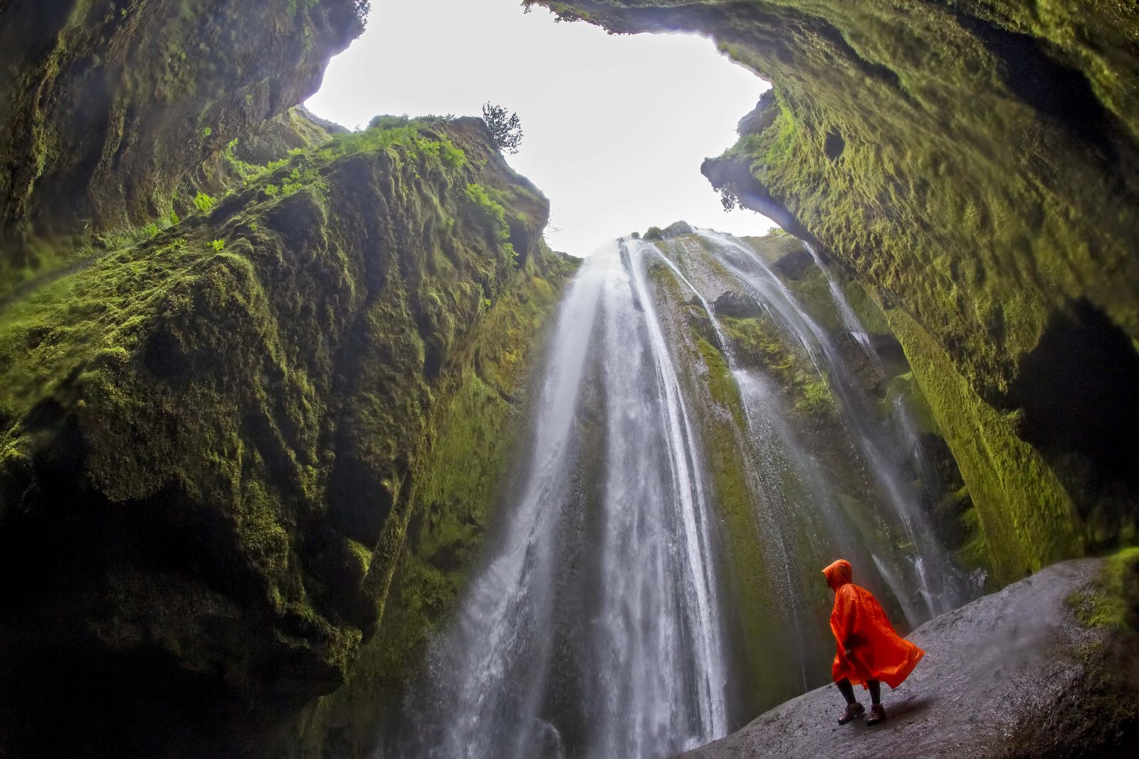
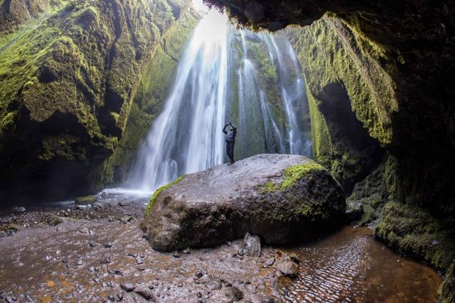
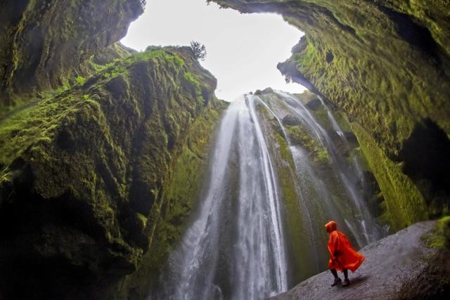
Gljúfrabúi is a few minutes' walk north of Seljalandsfoss, but you could easily walk past it. The waterfall, about 40 metres high, drops into a narrow gorge almost hidden behind a cliff. To see it properly you walk into the gorge along a shallow stream, where the fall lands in a small mossy chamber. A large rock in the middle lets you climb up for a better view.
The name means "dweller of the gorge". The fall is on the old farm of Hamragarðar, and a large rock called Franskanef stands in front of it, so from the path you see only the top of the water above the cliff. The stream runs out through a narrow cleft, and that cleft is your way in. After a few metres of wading the walls open into a round chamber, with the cliffs almost meeting overhead and moss on every surface. It looks like a film set, which is why photographers and wedding couples like it so much.
From Seljalandsfoss, follow the flat path north along the cliffs for roughly 600 metres, about 10 minutes. You use the same car park as Seljalandsfoss, which is paid (about 900 to 1,000 ISK per car in 2026). Expect wet feet and spray, so wear waterproof shoes and a rain jacket, and protect your camera. Gljúfrabúi is a protected natural monument, so leave the moss and rock as you find them.
2. Íráfoss waterfall
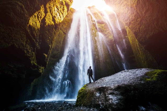
Íráfoss sits below the Eyjafjöll mountains, between Seljalandsfoss and Skógar, near the farm Ásólfsskáli. The Írá river comes down from the Eyjafjallajökull area and falls out of a small canyon over dark rock. Rounded boulders at the foot throw the water outwards, so from a distance the fall looks like a white skirt flaring at the hem. Dark basalt around it makes the white water stand out.
Very few people stop here, partly because there is next to nothing in the way of signs. From the Ring Road, take road 246, which loops north towards the mountains and rejoins the Ring Road a few kilometres further on. Follow it until you reach the bridge over the stream, where the waterfall comes into view. The GPS coordinates are 63.5782, -19.8262. The land around it is a working farm, and there is no marked trail to the fall itself, so park without blocking gates or tracks, take care on the uneven ground and respect the farmland.
3. Kvernufoss waterfall
Kvernufoss is just east of Skógafoss in the village of Skógar, yet most people who visit Skógafoss never see it. The fall, 30 to 40 metres high depending on which source you trust, drops into the Kvernugil gorge, and a path leads into the hollow behind the water, so you can walk behind it much as you can at Seljalandsfoss.
It looks like a slimmer version of its famous neighbour: a straight ribbon of water falling over dark rock into a green gorge. What it lacks is the staircase, the crowds and the tour buses. Some people call the gorge the concert hall of the elves, because of the way the sound of the water fills it.
Park at the Skógar museum, where parking is paid (about 750 ISK in 2026), then cross the fence by the small ladder and follow the path along the stream. It is about 1.4 kilometres return and takes roughly an hour at an easy pace. The walk is easy, with a few rocks to step over and some loose gravel. There is no deep cave behind the fall as there is at Seljalandsfoss, only an overhang, so you will get sprayed. Bring a rain jacket, and go slowly on the slippery path behind the water.

4. Loftsalahellir cave
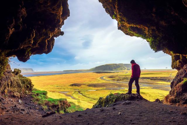
Loftsalahellir is a tuff cave in the side of Geitafjall mountain, on the road to Dyrhólaey, just west of Reynisfjara. From outside it looks like a green, mossy mound with a small opening. Inside is a wide hall with an open view over the Dyrhólaey area and the sea. Farmers in Mýrdalur used the cave as their assembly place before the district had a meeting hall, and fulmars nest in it. A rock nearby is called Gálgaklettur, the gallows rock, and old accounts say executions took place here, though there is little firm proof.
Photographers know it for the light and for the view out of the cave mouth, which frames green fields, Dyrhólaey and the sea.
Take road 218 towards Dyrhólaey; the turn-off from the Ring Road is opposite Skeiðflatarkirkja church. The cave is on the left about 3 kilometres along the road, before you reach the lighthouse, and there is a small free parking area. The cave is easy to miss without coordinates: 63.4219, -19.1518. The climb up takes less than five minutes but is steep and gets muddy after rain.
5. Hjörleifshöfði and the Yoda Cave
Hjörleifshöfði is a 221-metre hill standing alone on the black Mýrdalssandur plain, about 15 kilometres east of Vík. It formed late in the last ice age, in an eruption under the glacier, and was once an island in the sea.
According to the old Book of Settlements, it is named after Hjörleifur Hróðmarsson, who sailed to Iceland with his blood brother Ingólfur Arnarson, the first settler. The two were separated on the way. Hjörleifur landed here and built his farm, but was killed by his own Irish slaves, who fled with the boats. Ingólfur found the body, tracked the slaves to the islands off the coast and avenged him. The islands have been called Vestmannaeyjar, the islands of the west men, ever since. Hjörleifur's grave mound is said to be on top of the hill, and you can hike up to it in about an hour.
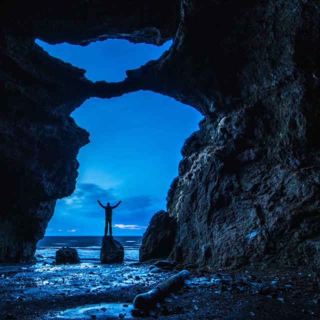
At the foot of the hill is Gígjagjá, better known as the Yoda Cave, because its opening looks like the head of the Star Wars character when seen from inside. Scenes from the Star Wars film Rogue One were filmed here. The tall opening and the moss on the dark rock make it a good place for photos, especially looking out from inside. A gravel track leads from the Ring Road to parking near the cave, and from there it is a short walk. Parking is paid (about 1,000 ISK in 2026). A standard car is usually fine in summer, but a 4×4 is safer in winter.
6. Stjórnarfoss waterfall
Stjórnarfoss is a short drive from Kirkjubæjarklaustur, at Kleifar near the farm Geirland. It is a wide, rounded fall of about 15 metres in two steps, framed by mossy slopes.
To find it, follow the Ring Road to the roundabout at Kirkjubæjarklaustur, turn towards the village and follow the sign for Geirland onto road 203. The waterfall is about 1.5 kilometres from the roundabout, and you see it before you reach the bridge. A faint path from near the bridge and the Kleifar campsite takes you to the base in a few minutes.
It is a good place for a picnic and to stretch your legs on the long drive east, and it is rarely crowded. The campsite is right next to the fall, so in summer you can pitch a tent and fall asleep to the sound of the water.
7. Rauðárfoss waterfall
Rauðárfoss, which means Red River Falls, is a small fall of about 20 metres near Kirkjubæjarklaustur. Rocks near the top split the water into thin strands, which is why it is often called a bridal veil waterfall, and iron in the soil gives the rock and the stream bed a reddish tone. The colour shows best when the water is low. In dry spells the fall can shrink to a trickle, and then the red rock behind it is the main sight.
Kirkjubæjarklaustur is a good base for this part of the coast. Nearby are Systrafoss, Kirkjugólf and the canyon at Fjaðrárgljúfur. Rauðárfoss is west of the village, beside the rock hill Systrastapi. Follow road 205 through the village and on along the gravel to a small parking area about 2.5 kilometres from the roundabout; the fall is a few hundred metres away at 63.7774, -18.0798. There are few signs, so ask locally about the path before you set out.
8. Múlagljúfur canyon
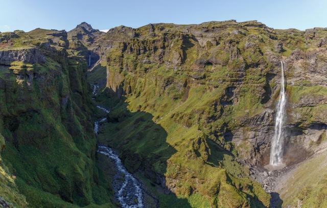
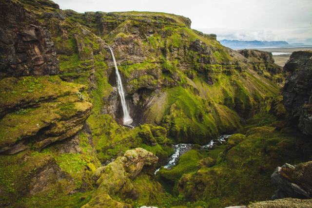
Múlagljúfur is a deep green canyon on the south side of Öræfajökull, between the hamlet of Hof and Fjallsárlón. The river Múlaá, fed by meltwater from the glacier, runs along the bottom. Two waterfalls fall into it: the tall, thin Hangandifoss, about 120 metres, and Múlafoss further in at the head of the canyon. The walls are covered in grass and bright moss, and from the upper viewpoint you can also look out over the glacier and the lagoon at its foot.
The canyon is easy to drive past. The turn-off from the Ring Road is about 14 kilometres west of Jökulsárlón and about 3 kilometres west of the road to Fjallsárlón, on the inland side. From there about 1.5 kilometres of rough gravel leads to the car park at 63.9905, -16.4244. Parking is paid (about 1,000 ISK per car in 2026, through the Parka app).
The hike follows the rim. The main viewpoint facing Hangandifoss is about 4 kilometres out and back, with about 190 metres of climbing and 35 to 60 minutes each way. The top viewpoint above Múlafoss is about 5.8 kilometres out and back with about 370 metres of climbing, 2 to 3 hours in total. The path is steep, uneven and slippery after rain, with two stream crossings and unfenced edges, so it is best in dry weather from June to September. If you would rather go with someone who knows the path, our Múlagljúfur canyon private tour takes you there with a guide.
9. Fjallsárlón glacier lagoon
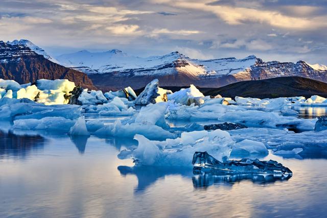
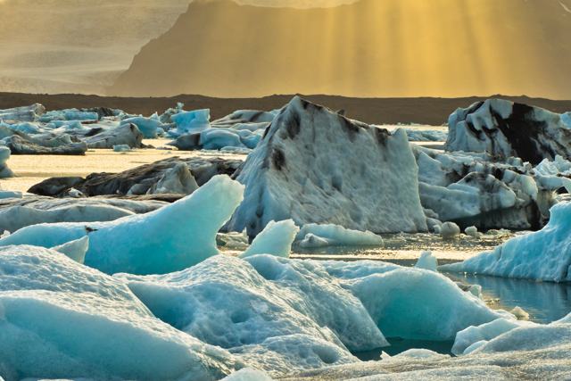
Fjallsárlón is a smaller sister of Jökulsárlón, about ten minutes' drive to the west. Here the Fjallsjökull outlet glacier, a tongue of Vatnajökull, comes right down to the lagoon, and icebergs break off into the water. Both lagoons come from the same ice cap, and Fjallsárlón has plenty of icebergs of its own, but it sits in the shadow of its famous neighbour. That is why it is usually calmer, and the glacier face is closer.
There is a visitor building with a small bistro, good for a hot drink after the wind off the ice. The boat operator says parking by the visitor building is free, though some 2026 fee lists show a charge at the lagoon, so check the signs when you arrive. Boat tours on the lagoon run from about April to November and take about 45 minutes on the water, or around 75 minutes including preparation. Children must be at least five to join. You can also just walk to the shore from the car park and watch the ice. In summer you may see great skuas on the gravel flats around the lagoon and, with luck, a seal in the water. Skuas nest on the ground and defend their nests, so keep your distance and leave the wildlife in peace. Read more in our guide to the glacier lagoons in Iceland, or book a trip on our glacier lagoon tours page. To reach this end of the coast in a day with your own guide, see our private Jökulsárlón glacier lagoon tour from Reykjavík.

Tips for visiting South Coast secret spots
- Plan by distance. Gljúfrabúi, Íráfoss, Kvernufoss and Loftsalahellir fit into a day from Reykjavík. The spots around Kirkjubæjarklaustur and Vatnajökull are best on a two- or three-day trip.
- Save the coordinates before you go. Íráfoss is at 63.5782, -19.8262, Loftsalahellir at 63.4219, -19.1518, Gljúfrabúi at 63.6209, -19.9862 and the Múlagljúfur car park at 63.9905, -16.4244. Signs are few and phone signal can drop.
- Several of these places are good for photography, weddings included. For anything more than a quick photo on private land, ask the landowner first.
- Expect paid parking at many sites. Most car parks use apps or number-plate cameras, so check the signs when you arrive.
- Stay on paths, do not walk on moss and close any gates behind you. Many of these places are on farmland.
- Wear waterproof shoes and a rain jacket. Several of these spots mean spray, mud or a stream crossing.
- In winter, days are short and paths can be icy. Check road.is for road conditions and vedur.is for the weather before you set off.
- Use a drone only where it is allowed. Read our drone flying guide first.
See them with a local guide
Big coach tours rarely have time for these detours. A small-group tour or a private South Coast tour can add a quiet stop or two, and the guide knows when each place is at its best. Browse our South Coast tours from Reykjavík, private tours and 2- and 3-day tours, which often reach Fjallsárlón and Jökulsárlón.
Planning your own trip? See our self-drive tours, such as the 5-day self-drive along the South Coast to the Glacier Lagoon, our list of the top 103 locations in Iceland and our guide to how many days you need in Iceland.
If you want a guide to plan the detours for you, these are good places to start:
- Private South Coast Tour: your own guide and vehicle, so you can ask for a quieter waterfall or cave on the way.
- 2 Day South Coast Private Tour: two days with a private guide, with time to go further east than a day trip allows.
- South Coast & Glacier Lagoon in 5 Days: car, hotels and a day-by-day plan, if you prefer to find these spots at your own pace.

Questions people ask
What are the best secret locations in South Iceland?
Good quieter stops include Gljúfrabúi and Kvernufoss waterfalls, Loftsalahellir cave, the Yoda Cave at Hjörleifshöfði, Múlagljúfur canyon and Fjallsárlón glacier lagoon. All are a short detour from the Ring Road.
Can you walk behind waterfalls in South Iceland other than Seljalandsfoss?
Yes. At Kvernufoss, near Skógafoss, a path leads into the hollow behind the water. At Gljúfrabúi you walk into a narrow gorge to stand close to the fall.
Do you have to pay for parking at these places?
At several of them, yes. In 2026, Seljalandsfoss and Gljúfrabúi, the Skógar museum car park for Kvernufoss, Hjörleifshöfði and Múlagljúfur all charge for parking. At Fjallsárlón the boat operator says parking by its visitor building is free, but check the signs.
Is Múlagljúfur canyon hard to hike?
It is moderate. The main viewpoint is about 4 km out and back with about 190 metres of climbing; the top viewpoint is about 5.8 km with about 370 metres. The path is steep and uneven, with two stream crossings and unfenced edges. Go in dry weather and wear good boots.
Is Fjallsárlón better than Jökulsárlón?
It is not better, just different. Fjallsárlón is smaller and usually quieter, with the glacier close to the shore. Jökulsárlón is bigger and next to Diamond Beach. They are about ten minutes apart, so many people visit both.
How do I find Gljúfrabúi, the waterfall hidden in a gorge?
Park at Seljalandsfoss and walk north along the cliffs for about 10 minutes to Hamragarðar. A stream runs out of a cleft in the cliff. Wade in along the stream for a few metres and the waterfall is inside.
Why is it called the Yoda Cave?
The opening of the cave Gígjagjá at Hjörleifshöfði looks like the head and ears of Yoda from Star Wars when you stand inside and look out. Scenes from Rogue One were also filmed here.