Iceland Travel GuideLOCAL TRAVEL AGENCY IN ICELAND
My trip
Talk to a local
Iceland Travel GuideLOCAL TRAVEL AGENCY IN ICELAND
My trip
Talk to a local
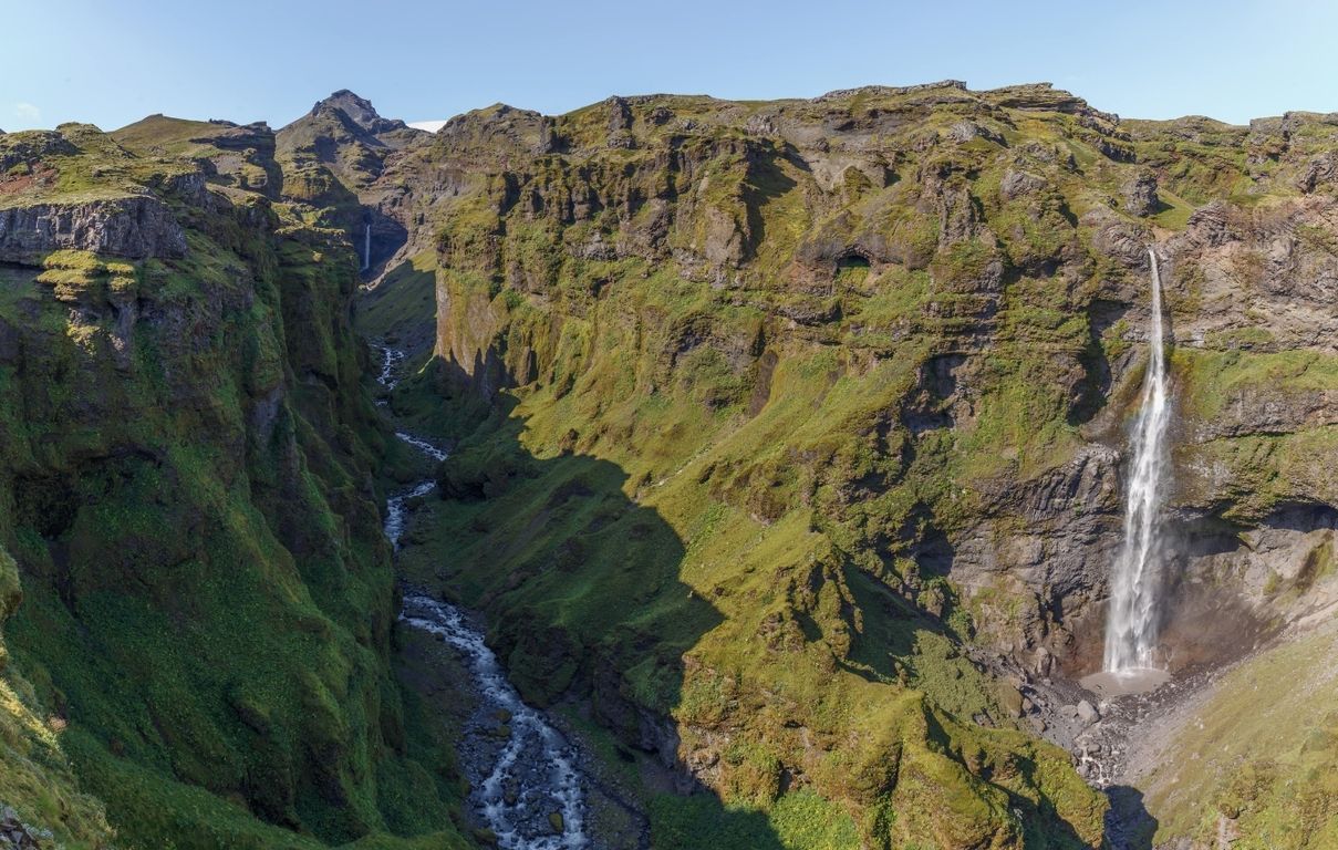
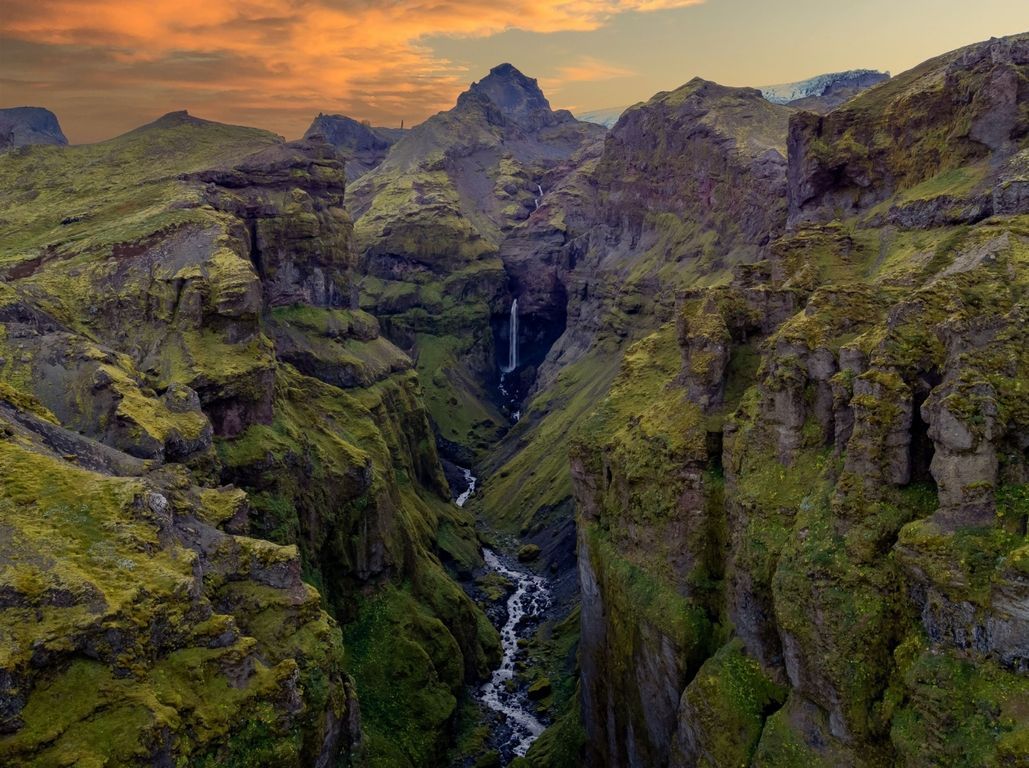
Múlagljúfur canyon is a green, steep-sided gorge in Southeast Iceland, on the slopes of Öræfajökull about 13 km west of Jökulsárlón glacier lagoon. A free, unmarked out-and-back hike of roughly 5–7 km climbs to a viewpoint opposite Hangandifoss, a waterfall of about 120 m. Allow 2–3 hours. The hike is best from June to September, and there are no facilities at the trailhead.
Múlagljúfur is one of the most rewarding short hikes in the Öræfi district between Skaftafell and Jökulsárlón, yet it has no signpost on the Ring Road, so most traffic drives straight past. The path climbs along the rim of the canyon, with views back over Fjallsárlón glacier lagoon, the outlet glaciers of Vatnajökull and the flat sands towards the sea, before reaching a viewpoint across from the falls.
The main sight is Hangandifoss, which means 'hanging waterfall'. A side stream reaches the edge of the canyon and plunges about 120 m into a mossy grotto below, which puts it among the tallest waterfalls in Iceland. Further along the canyon is a second, smaller fall, Múlafoss. Light is often best in the afternoon and evening in summer, when the sun reaches into the gorge.
Because it takes some effort, Múlagljúfur canyon stays far quieter than the roadside stops nearby. It fits well into a day that also includes Fjallsárlón, Jökulsárlón and the Diamond Beach, or a morning before driving west to Skaftafell. It is about 370 km from Reykjavík, so it is best visited on a multi-day South Coast trip rather than a day trip.
The trail is not marked and has no railings along the canyon edge. It is not suitable for small children or anyone unsteady on narrow, exposed ground, and it is best avoided in strong wind.
Finding the start is the part that confuses most first-time visitors. Do not count on signs: put the coordinates into your map before you leave, while you still have a good signal.
If the gravel road looks too rough for your car, do not force it. Park where it is safe and legal near the Ring Road and walk in, which adds about 2 km each way.
The route is out and back on the same path. It is 35–60 minutes each way to the main viewpoint, depending on your pace, and 2–3 hours in total if you carry on to the top. The marker posts are small and many are worn down, so follow the trodden path and look for the next post before you move on.
Going down takes almost as long as going up, because the steep parts are slippery. Walking poles help on the descent.
The hike is short, but the view changes all the way up, which is why people spend longer here than they planned.
Wear hiking boots with a good grip, not trainers. Bring a waterproof jacket and trousers, a warm layer, water and snacks or a packed lunch. In spring and autumn the path is often muddy, and in winter you need ice grips or crampons and experience of walking on snow and ice.
The hike is possible all year when there is little snow, but because the path is not well marked it is easy to lose under snow. We recommend going between late April and early October.
Check three things on the day: the weather forecast for rain and wind (Belgingur or the Icelandic Met Office at vedur.is), SafeTravel (safetravel.is) for warnings and travel advice, and the road conditions map at umferdin.is for closures and webcams. Wind on the ridge is much stronger than at the car park, so if a wind warning is in force, leave the hike for another day.
Check the weather forecast on vedur.is and conditions on safetravel.is on the morning of your hike, as wind off the glacier can be strong.
There are no toilets, bins or services at the trailhead, only a small gravel car park. The nearest toilets and cafés are at Fjallsárlón and Jökulsárlón, and the nearest fuel is at Skaftafell or Höfn.
There is no village at Múlagljúfur. Most people stay at hotels and guesthouses around Skaftafell and Hof, near Kirkjubæjarklaustur to the west or in Höfn about an hour east. Hotels in this area can be added to your trip in our trip planner, and our 5-Day South Coast Self-Drive to Jökulsárlón includes two nights in the Skaftafell and Kirkjubæjarklaustur area, which puts the canyon within an easy drive.
About 5–7 km return from the car park, depending on how far along the rim you go, with roughly 300–450 m of climbing. Most people need 2–3 hours.
It is easy to moderate. The path is steep in places, loose and unmarked, with a short narrow stretch along the canyon edge. Anyone with reasonable fitness and good boots can do it in dry weather. Our private tour to the canyon is suitable from age 8.
At a small free car park at the end of a rough gravel track that leaves Route 1 about 13 km west of Jökulsárlón. The turn-off has no sign.
About 120 m. The water drops from a side valley into the canyon, which is why it is called the hanging waterfall.
We don't recommend it. Ice and snow on the steep path near the edge make it dangerous, and our guided hike runs from June to September only.
About 13 km, or 15 minutes, west of Jökulsárlón, and about 370 km, or 4.5–5 hours, from Reykjavík.
Yes, on our Múlagljúfur Canyon Private Tour, which takes 12–13 hours with stops at Seljalandsfoss and Skógafoss. Driving yourself, it is easier to stay a night near Skaftafell.
Yes, if you enjoy hiking. It is one of the quietest viewpoints in South Iceland, with a 120 m waterfall and views over Fjallsárlón and Vatnajökull.
Tours and trips that include Múlagljúfur, booked directly with a local travel agency in Iceland.