Iceland Travel Guide logo Iceland Travel GuideLOCAL TRAVEL AGENCY IN ICELAND My trip Talk to a local
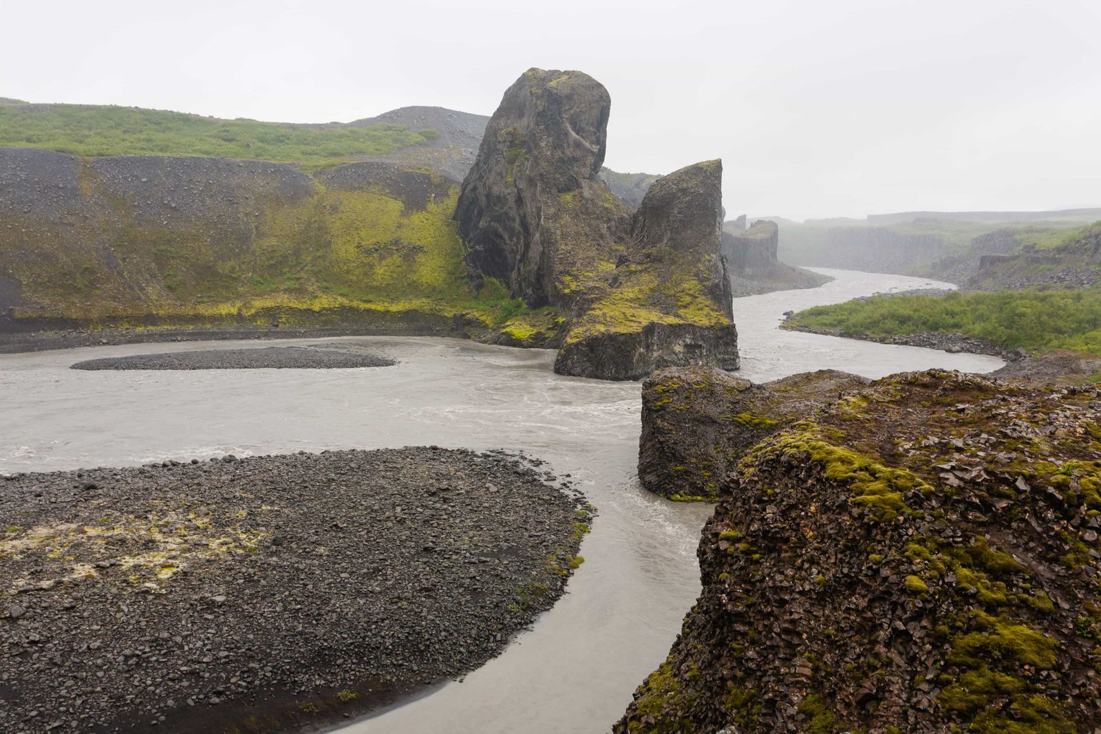
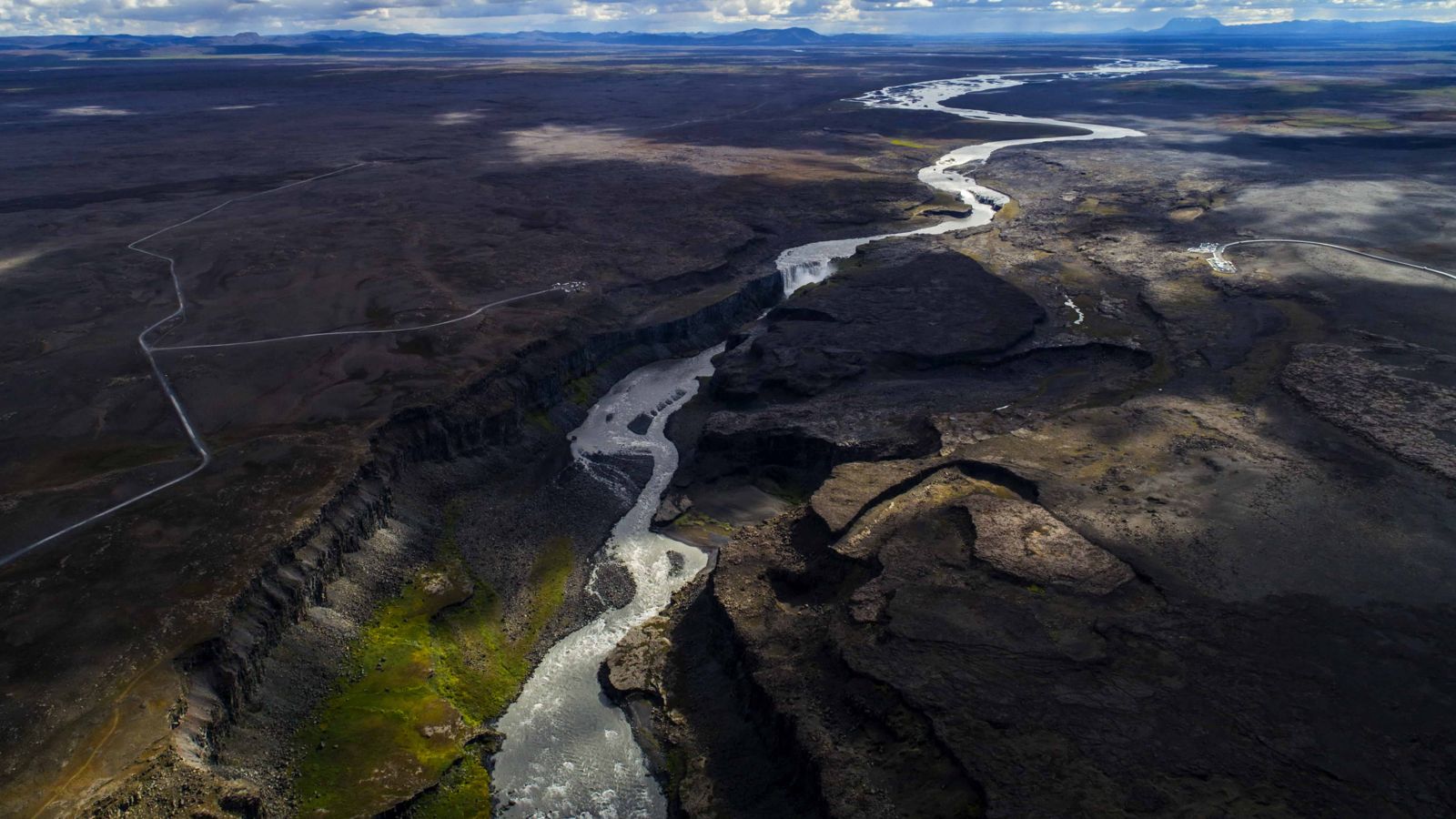
Jökulsárgljúfur canyon

Diamond CircleCanyonFree entrySummer easiest
JÖKULSÁRGLJÚFUR IN SHORT

Jökulsárgljúfur is a canyon about 25 km long and over 100 m deep, cut by the Jökulsá á Fjöllum river and glacial floods in North Iceland. It is part of Vatnajökull National Park and a main stop on the Diamond Circle, about 540 km (around 7 hours) from Reykjavík. Entry is free, and a visit to the main sights takes half a day to a full day.

ON THIS PAGE
Quick factsHistoryGetting thereHighlightsHikingWhich carBest time to visitSafety tipsFacilitiesMapNearbyWhere to stayFAQ

About Jökulsárgljúfur

Jökulsárgljúfur, which means glacial river canyon, was carved by the Jökulsá á Fjöllum, one of Iceland's largest rivers, together with catastrophic glacial outburst floods from Vatnajökull. The canyon is about 25 km long, around 500 m wide and more than 100 m deep in places. It holds some of North Iceland's best-known sights in a fairly compact area: Dettifoss and the neighbouring falls Selfoss, Hafragilsfoss and Réttarfoss, the horseshoe-shaped valley of Ásbyrgi, and the odd rock formations of Hljóðaklettar.

The scale of the canyon, rather than any single waterfall or formation, is what stays with people: sheer basalt walls, a wide flood-carved riverbed and volcanic hills such as the red Rauðhólar. Between Ásbyrgi in the north and Dettifoss in the south there are marked trails, from short walks to a two-day trek.

Quick facts

LengthAbout 25 km (sources give 24–25 km)
Width and depthAbout 500 m wide, more than 100 m deep in many places (up to about 120 m)
RiverJökulsá á Fjöllum, fed by Vatnajökull
RegionNorth Iceland, part of Vatnajökull National Park
From ReykjavíkAbout 540 km to Ásbyrgi, around 7 hours by car; about 530 km and 6.5 hours to Dettifoss
From HúsavíkAbout 62 km to Ásbyrgi, around 45 minutes by car
From AkureyriAbout 130 km to Dettifoss (around 2 hours) and about 150 km to Ásbyrgi
EntryFree entry and parking
Opening hoursAccessible all year, but Route 864 and some trails are only usable in summer
Time neededHalf a day to a full day for the main sights
ProtectedPart of Vatnajökull National Park since 7 June 2008 (previously its own national park)

Carved by floods

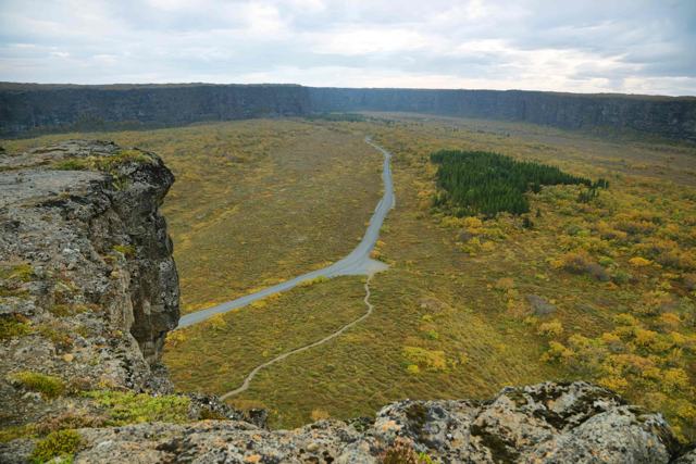
Jökulsárgljúfur lies in Iceland's northern volcanic zone, where volcanoes under the Vatnajökull ice cap have repeatedly triggered huge floods, called jökulhlaups. These floods tore out the canyon and shaped Ásbyrgi, a horseshoe-shaped valley about 3.5 km long with walls up to 100 m high. Sources date the floods differently, from roughly 8,000–10,000 years ago to about 2,000–3,000 years ago.

The area became its own national park and was merged into Vatnajökull National Park on 7 June 2008. Park rangers work here year-round.

How to get to Jökulsárgljúfur

On a guided tourDay tours on the Diamond Circle from Akureyri, Mývatn or Húsavík usually include stops in Jökulsárgljúfur, such as Dettifoss and Ásbyrgi.
By carRoute 862 (Dettifossvegur) runs along the west side of the canyon from the Ring Road and is paved and suitable for ordinary cars. Route 864 on the east side is a rough gravel road, and a 4x4 is recommended. Ásbyrgi is reached from the north on Route 85.
By public transportThere is no regular public bus into the canyon, so a car or a tour is the practical option.

In winter, Route 862 has limited snow clearing and storms can block it for days. Route 864 is not maintained in winter. Check umferdin.is before you go from October to May.

Main sights in the canyon

Jökulsárgljúfur covers a large area, and most visitors focus on a few key spots along it.

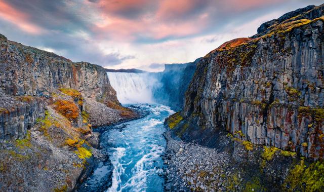
DettifossOne of Europe's most powerful waterfalls by volume, about 100 m wide and dropping about 44 m into the canyon. There is a viewing area on each side of the river: the west side is reached on Route 862 and the east side on Route 864.
ÁsbyrgiA horseshoe-shaped valley at the northern end, with a forested floor, a central rock called Eyjan and a still pond beneath the cliffs. Paths range from about 30 minutes to longer hikes.
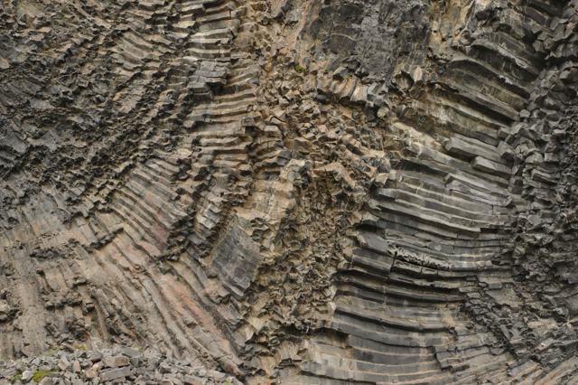
HljóðaklettarBasalt columns and cave-like shapes in Vesturdalur, in the middle of the canyon, reached by a short and easy marked trail from the Vesturdalur car park. The name means rocks of echoes. Vesturdalur is also a good place to take in the scale of the canyon.
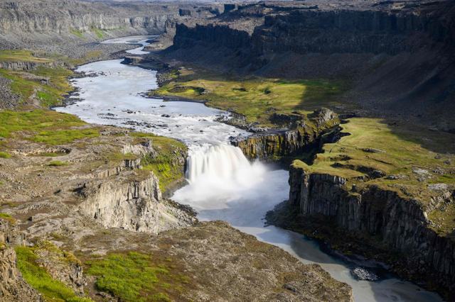
Selfoss and HafragilsfossTwo more waterfalls on the river. Selfoss is a short walk upstream from Dettifoss and well worth the extra time. Hafragilsfoss, downstream, is smaller than Dettifoss and you cannot get as close to it, but the view into the canyon from above is one of the best.

Hiking in Jökulsárgljúfur

The canyon is best seen on foot, and the marked trails run from short strolls to a two-day trek.

Dettifoss to SelfossA short, mostly flat walk upstream along the canyon edge from Dettifoss to the wide Selfoss waterfall and back.
Hljóðaklettar loopA short and easy trail from Vesturdalur through the echo rocks, with longer loops if you want more.
Hólmatungur to VesturdalurA walk of three to four hours past the springs and small waterfalls of Hólmatungur down to Vesturdalur. Starting all the way back at Dettifoss makes it a long day.
Dettifoss to ÁsbyrgiThe full canyon trail, usually walked in two days with a night at the Vesturdalur campsite.
ÁsbyrgiEasy paths on the wooded floor of the horseshoe canyon, under cliffs of 90–100 m on every side except the north, where the walls drop away to the lowland.

Ask the rangers at Gljúfrastofa in Ásbyrgi about trail conditions before a longer hike, and carry water.

Which car do you need

A small two-wheel-drive car is fine for the main roads here in summer: the Ring Road, Route 85 to Ásbyrgi and the paved Route 862 to Dettifoss. Front-wheel drive is the usual choice in Iceland. Think about luggage when you book, because a fully loaded small car is harder work on gravel.

Route 864 on the east side and some side roads into the canyon are gravel and can be rough. A 4x4 is more comfortable there, although a careful driver in a two-wheel-drive car manages them in summer. In winter, follow the forecast on vedur.is and the road conditions on umferdin.is closely, and be ready to change plans.

Best time to visit Jökulsárgljúfur

Summer (June–August)All roads and paths are normally open, including Route 864 and the Vesturdalur campsite, and this is the easiest time to see the full canyon.
Winter (October–April)Route 864 is closed and Route 862 can be blocked by snow. Daylight is short, and trails can be icy. Check conditions before visiting.

Ásbyrgi can be visited at any time of year, and Route 85 from Húsavík stays open through the winter. Dettifoss, Selfoss, Hafragilsfoss and Vesturdalur lie higher up and get deep snow, so they are not recommended in cold weather unless the road is confirmed open. Services are limited everywhere outside summer.

Safety and practical tips

  • Plan a full day if you want to see Dettifoss, Ásbyrgi and Hljóðaklettar in one visit, as distances are longer than they look on a map.
  • Check road conditions before visiting outside summer; Route 864 has no winter maintenance.
  • Stay on marked paths and behind barriers near canyon edges, which can be unstable and slippery with spray.
  • Bring water and snacks, as facilities away from Ásbyrgi are limited.
  • Wear waterproof clothing. Spray at Dettifoss soaks you quickly.

Facilities and accessibility

Gljúfrastofa visitor centre at Ásbyrgi has toilets, an exhibition and a small shop. It is open daily 9:00–18:00 in June to August, 10:00–17:00 in May, September and October, and weekdays 11:00–15:00 in the rest of the year (closed late December). Ásbyrgi also has a campsite (mid-May to October), a restaurant and a shop. There is a tent-only campsite at Vesturdalur in summer.

On the map

Open in Google Maps →

Nearby places worth a stop

ÁsbyrgiÁsbyrgiHorseshoe canyon at the northern end of JökulsárgljúfurDettifossDettifossPowerful waterfall within the canyonHafragilsfossHafragilsfossWaterfall just downstream from DettifossHljóðaklettarHljóðaklettarUnusual basalt rock formations within the canyonHúsavíkHúsavíkNearest coastal town, known for whale watchingSelfossSelfossWide waterfall a short walk upstream from DettifossNámaskarð (Hverarönd)Námaskarð (Hverarönd)Hot springs, fumaroles and mud pots near MývatnMývatnMývatnLake area with craters, lava and nature baths

Where to stay near Jökulsárgljúfur

Húsavík, Ásbyrgi and the Mývatn area all have accommodation, and any of them works as a base for a day in Jökulsárgljúfur as part of the Diamond Circle. Ásbyrgi has a campsite. The Ásbyrgi campsite is large and well equipped and sits by the visitor centre, which makes it the most practical place to stay in the canyon. Vesturdalur, about halfway between Dettifoss and Ásbyrgi, has a simple campsite with few services.

Jökulsárgljúfur FAQ

What is Jökulsárgljúfur?

A canyon about 25 km long, cut by the Jökulsá á Fjöllum river and glacial floods. It contains Dettifoss, Ásbyrgi and Hljóðaklettar and is part of Vatnajökull National Park.

How long do you need to see Jökulsárgljúfur?

Half a day at minimum to see one or two main sights; a full day to cover Dettifoss, Ásbyrgi and Hljóðaklettar.

Is there an entry fee?

No. Entry and parking are free.

Is Jökulsárgljúfur part of the Diamond Circle?

Yes, it is one of the main stops on the Diamond Circle in North Iceland, along with Mývatn, Húsavík and Goðafoss.

Can you visit in winter?

Yes, but access is limited. Route 864 is closed and Route 862 can be blocked by snow. Summer is the easiest time to visit.

Do you need a 4x4 for Jökulsárgljúfur?

Not for the main sights in summer. Route 862 to Dettifoss and Route 85 to Ásbyrgi are fine in an ordinary car. A 4x4 is better for the gravel Route 864 on the east side.

Where can you stay in Jökulsárgljúfur?

There is a large campsite at Ásbyrgi beside the visitor centre and a simple one at Vesturdalur. Húsavík and the Mývatn area have hotels and guesthouses.

How do you get to Ásbyrgi from Húsavík?

Follow Route 85 for about 60 km, around 45 minutes. The road is open all year.
More places in North Iceland