SELFOSS IN SHORTSelfoss is a wide, horseshoe-shaped waterfall about 10 metres high on the Jökulsá á Fjöllum river, a short walk upstream from the much larger Dettifoss. It is in Vatnajökull National Park in North Iceland, free to visit, and usually combined with a visit to Dettifoss as a round trip of around 2.5 km and about an hour on foot.
About Selfoss
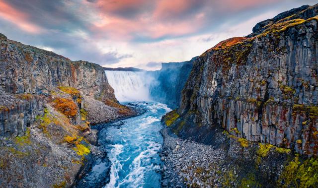
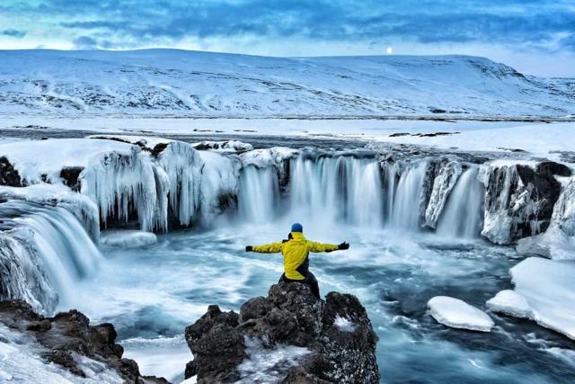
Selfoss sits just upstream of Dettifoss on the same glacial river, the Jökulsá á Fjöllum, but it is a very different kind of waterfall. Instead of one huge drop, the river spreads out over a wide, curved lip of rock, making it feel gentler and more spread out than its famous neighbour. Most visitors walk there directly from the Dettifoss car park.
The path follows the canyon rim, giving good views down into the gorge along the way. It is a worthwhile add-on for anyone already stopping at Dettifoss, since the contrast between the two falls, one powerful and narrow, one wide and multi-stranded, is part of what makes the walk interesting.
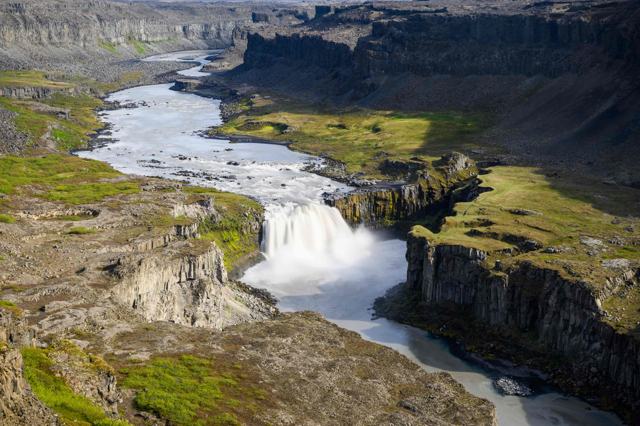
Selfoss is only about 10 to 11 metres high, but it is roughly 100 metres wide. The Jökulsá á Fjöllum is the second-longest river in Iceland and carries meltwater from the Vatnajökull glacier, so the water is grey-brown with silt and the flow changes with the season and the weather. The river runs along a horseshoe-shaped ledge and drops in a long row of separate curtains down the canyon wall, with mist hanging over the gorge on calm days.
It is the first of three big waterfalls on this stretch of the river. Dettifoss, the most powerful waterfall in Iceland, is about 1 km downstream, and Hafragilsfoss is roughly 2.5 km below that. All three are in the Jökulsárgljúfur canyon, the northern part of Vatnajökull National Park.
You can walk to Selfoss on either bank, but the two sides are reached by different roads, there is no way across the river at the falls, and the views are not the same. From the west you stand close to one end of the falls and see part of it. From the east you see the whole horseshoe. It is worth choosing your side before you drive.
Quick facts
HeightAbout 10–11 m
WidthAbout 100 m
RiverJökulsá á Fjöllum, Iceland's second-longest river
RegionNorth Iceland, Jökulsárgljúfur in Vatnajökull National Park
GPS of the waterfall65.8056, -16.3861
From DettifossAbout 1 km upstream, roughly 20–30 minutes' walk
West side loop (car park, Dettifoss, Selfoss)About 2.5 km, around 1 hour, easy but rocky
East side walk (Dettifoss and Selfoss)Rougher, with boulders; allow about 1.5 hours
RoadRoute 862 (west side, paved) or Route 864 (east side, gravel)
East side road seasonRoughly late May or June to early October
From AkureyriAbout 133 km, around 1 hour 45 minutes to the west car park
Entry and parkingFree
Opening hoursAlways open, but road access is seasonal
How to get to Selfoss
On a guided tourSelfoss is usually included as a short add-on walk on Dettifoss and Diamond Circle tours from Akureyri or Mývatn. In winter a tour in a suitable vehicle is the safest way to get here.
From ReykjavíkDrive north on Route 1, the Ring Road, through Borgarnes, past Laugarbakki and Varmahlíð to Akureyri, about 390 km and around 5 hours. From Akureyri continue east on the Ring Road past Lake Mývatn and Reykjahlíð. It is too far for a day trip from Reykjavík, so plan it as part of a North Iceland or Ring Road trip.
West side by car (Route 862)East of Mývatn, turn north off the Ring Road onto Route 862. The road is paved all the way to a large car park, about 25 minutes from the junction. This is the easier road and the side most visitors use. From Akureyri it is about 133 km and 1 hour 45 minutes.
East side by car (Route 864)Carry on along the Ring Road across the bridge over the Jökulsá á Fjöllum, then turn north onto Route 864 (Hólsfjallavegur). It is a narrow gravel road with rough patches and potholes. A normal car can manage it in summer if you drive slowly, but it takes time.
ParkingThere is a free car park on each side of the river, with room for plenty of cars on the west side. You cannot drive to Selfoss itself; both car parks are for Dettifoss, and you walk upstream from there.
Hiking thereFrom either Dettifoss car park, follow the marked trail to Dettifoss and then the signed path upstream along the canyon rim for about 1 km to Selfoss. The step-by-step route for each side is below.
The eastern road (864) has no winter service. It closes when the first snow falls in autumn and usually reopens in late May or June, once the road has dried out. The western road (862) has limited winter service and is often not cleared at all from January to early April, so closures can last into April or May. Check umferdin.is for road conditions and alerts before you set off, at any time of year.
The hike from Dettifoss to Selfoss
Both waterfalls can be seen from the west side or the east side of the river. The walk is short on either bank, but the ground is rock, sand and boulders rather than a built path, so give yourself time.
West side, step 1: car park to DettifossFrom the big car park on Route 862, follow the marked path across the rocky plateau to Dettifoss. Take your time at the viewpoints. This side catches the spray, so expect to get damp near the lower viewpoint when the wind blows your way.
West side, step 2: Dettifoss to SelfossFrom the lower Dettifoss viewpoint, start back towards the car park and look for the sign to Selfoss. A separate trail runs upstream beside the river for about 1 km over rocky ground. The west bank gives only a partial view of Selfoss, but you can get close to the falls.
West side, step 3: back to the car parkFrom Selfoss, follow the trail and the signs for the parking area. The full loop from the car park to Dettifoss, on to Selfoss and back is about 2.5 km and takes around an hour. The national park grades it as an easy walk.
East side, step 1: car park to DettifossFrom the car park on Route 864, a steep, rocky trail leads down to Dettifoss in about 10 minutes (roughly 400 metres). There are several good spots for photos on the way down, and on a sunny day you may see a rainbow in the mist. You stand very close to the edge here and usually stay dry, as the spray tends to blow the other way.
East side, step 2: Dettifoss to SelfossThe trail carries on upstream for about 1 km. It is rougher than the west side, crossing bare basalt, black sand and stretches of large boulders that you have to scramble over, which children often enjoy. Your reward is the full view of Selfoss, with water falling in curtains along the whole length of the horseshoe.
East side, step 3: time and distanceReturn the same way. Seeing both waterfalls from the east side takes about an hour and a half. The going is slower than the distance suggests because of the boulders, so do not rush it.
Which side should you choose? If you want the easier road, the easier walk and a visit outside high summer, go west. If you are here between June and September, do not mind a slow gravel road and want the best view of Selfoss, go east. Driving from one car park to the other means going back to the Ring Road and takes an hour or more, so most people pick one side.
Dettifoss is known for its power, and Selfoss for its shape. Seeing the two together, a kilometre apart on the same river, is the reason to add the extra walk.
There are no railings at Selfoss and the rock at the rim can be wet, loose or icy. Keep well back from the edge and keep children close.
Best time to visit Selfoss
Summer (June–August)The best time to visit. Both roads are normally open, the weather is milder and the long daylight gives you time for both waterfalls. The river is also at its fullest, because glacier melt peaks in summer.
Spring and autumnIn May and September to October the west side is usually reachable, but the east road may still be closed or may close with the first snow. Expect mud, patches of snow and cold wind on the trail.
WinterThe area is far quieter, but the roads to both sides are often closed, sometimes until April or May. If the west road is open, the trail can be icy or buried in snow and the path to Selfoss may be hard to follow.
Whatever the season, the weather on this high, open plateau changes fast. Check the forecast on vedur.is and the roads on umferdin.is on the morning of your visit.
Safety and practical tips
- Wear sturdy, waterproof shoes; the trail is rocky, uneven and sometimes muddy.
- Stay back from the canyon edge, especially where the ground is wet or icy. There are no railings at Selfoss.
- Bring a waterproof jacket on the west side, where the spray from Dettifoss can soak you.
- Combine Selfoss with Dettifoss in one visit, since the trail connects them from the same car park.
- Check road conditions before driving. Route 864 is gravel and closed in winter, and Route 862 can close in snow.
- Bring water and something to eat. There is no shop, café or fuel at the falls.
- Stay on the marked trail and respect any closures; the park closes paths when ice or meltwater makes them unsafe.
- On the east side, allow extra time for the boulder sections and help children over them.
Facilities and accessibility
There are basic toilets at the Dettifoss car parks. There is no café, shop or fuel on site, and overnight parking is not allowed. The paths are rough and rocky on both sides, so they are not suitable for wheelchairs or pushchairs. The nearest services are around Mývatn and in Ásbyrgi.
Nearby places worth a stop
Where to stay near Selfoss
Most visitors see Selfoss on a day trip from Akureyri or the Mývatn area. If you have the time, make it a trip of two or more days and stay in Akureyri, around Mývatn or along the Diamond Circle, for example near Húsavík or Ásbyrgi. That gives you time for both waterfalls, the canyon and the lake without rushing.
Selfoss FAQ
Is Selfoss the same as the town Selfoss in South Iceland?
No, this Selfoss is a waterfall in North Iceland, near Dettifoss. There is a separate town of the same name in South Iceland.
How do I get from Dettifoss to Selfoss?
Follow the signed path upstream along the canyon rim, about 1 km each way. On the west side the full loop from the car park to both waterfalls and back is about 2.5 km and takes around an hour.
Which side is better for Selfoss, east or west?
The east side gives the full view of the horseshoe, but the road is gravel and the trail has boulders. The west side has a paved road and an easier walk, and you get close to the falls but see only part of them.
How high is Selfoss waterfall?
About 10 to 11 metres high and roughly 100 metres wide. It is much lower than Dettifoss, which drops about 44 metres, but far longer along its edge.
Is it free to visit?
Yes, there is no entrance fee and parking is free.
Can I visit Selfoss in winter?
Sometimes. The east road is closed all winter and the west road has limited winter service, so it is often shut for weeks at a time. Check umferdin.is, and consider a guided tour in a suitable vehicle.
Can I visit Selfoss without seeing Dettifoss?
You can, but the trail starts from the Dettifoss car parks and the two are only a kilometre apart, so most people walk to both.
How do I drive to Selfoss from Akureyri?
Take the Ring Road east past Lake Mývatn, then turn north on Route 862 for the west side or Route 864 for the east side. It is about 133 km and 1 hour 45 minutes to the west car park.
 Iceland Travel GuideLOCAL TRAVEL AGENCY IN ICELAND
My trip
Talk to a local