Iceland Travel GuideLOCAL TRAVEL AGENCY IN ICELAND
My trip
Talk to a local
Iceland Travel GuideLOCAL TRAVEL AGENCY IN ICELAND
My trip
Talk to a local
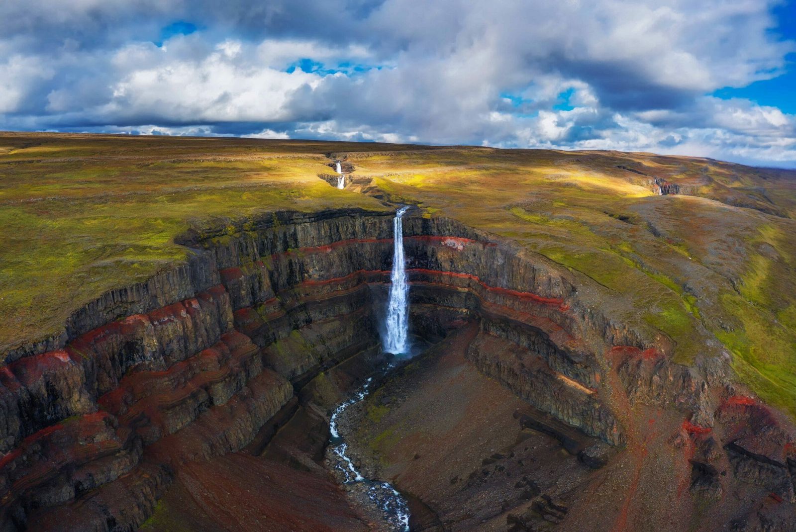
Hengifoss is a 128-metre waterfall above Lagarfljót lake in East Iceland, about 35 km (roughly 30 minutes) from Egilsstaðir. There is no entry fee, only a parking charge, and it is open all year, but reaching it means a hike of about 2.5 km each way, taking most people 2 to 3 hours round trip.
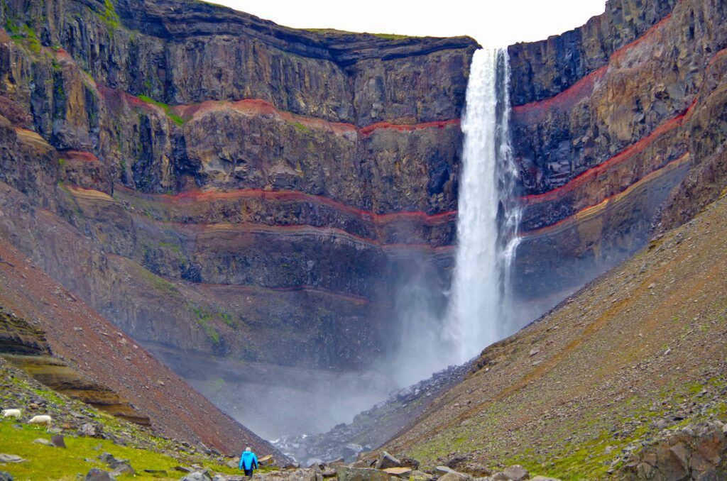
Hengifoss is one of the tallest waterfalls in Iceland and the best-known hike in the east of the country. The water drops in a single narrow fall down a cliff streaked with thin, reddish bands of clay between darker layers of basalt, a pattern that formed over millions of years as lava flows and quieter periods alternated.
Where is Hengifoss located? It is in Fljótsdalur valley on the west side of Lagarfljót, the long lake that runs south from Egilsstaðir. This part of the country sees far fewer visitors than the South Coast, so even in July the trail rarely feels crowded.
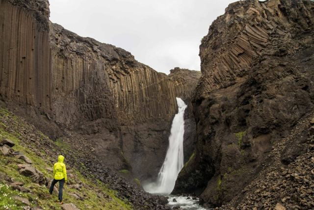
The trail up from the car park follows the Hengifossá river and passes Litlanesfoss on the way, so most visitors treat the two waterfalls as one outing. The path climbs steadily and gets steeper near the top, but it is well marked and needs no special gear beyond decent shoes and a rain jacket.
The hike is moderate. You gain close to 300 metres over 2.5 km, with a few steep stretches, and you are in the open the whole way, with views back over Lagarfljót and the mountains beyond from the very first minutes. People who walk regularly manage it comfortably; families with children do it too, just more slowly.
What sets Hengifoss apart from other tall waterfalls in Iceland is the cliff behind it. Dark basalt and thin red clay alternate all the way up the wall of the gorge, so you are looking at a cross-section of several million years of eruptions in one view. Add the basalt columns of Litlanesfoss on the way up and you get two very different waterfalls on one trail.
The red bands in the cliff at Hengifoss are old, oxidised layers of clay and soil that built up between eruptions, millions of years ago when this part of Iceland had a warmer, wetter climate than today. Fossilised tree trunks and traces of lignite have been found in the area, evidence of forests that grew here long before the ice ages shaped the landscape into what you see now.
The dark layers are lava flows that cooled into basalt, one on top of another. Between eruptions there were long quiet periods when soil built up on the surface. The next lava flow buried and baked that soil, and the iron in it turned red. Erosion by the river has since cut the gorge and exposed the whole stack.
Geologists have used the exposed layers at Hengifoss to study Iceland's volcanic and climate history, since each band of rock and clay records a different period. For most visitors it is simply a dramatic backdrop, but it is worth knowing that the reddish stripes are not paint or mineral staining, they are ancient soil.
The path can be muddy and slippery after rain, and icy in winter, so check conditions locally before setting out in the colder months.
The trail is 2.5 km each way and climbs close to 300 metres. It is well marked and well maintained, and you cannot really get lost: you follow the Hengifossá gorge uphill the whole way.
Paths now run on both sides of the gorge, linked by footbridges, so you can go up one side and come down the other if conditions allow.
Wear sturdy hiking shoes or boots, bring water and a snack, and dress in layers. There is no shelter on the trail, and even in summer it can be cool and windy at the top when it was calm at the car park. A waterproof jacket covers both the weather and the spray. In winter add ice spikes, hat and gloves, and a headlamp if you are starting late, since daylight is short.
Hengifoss fits well into a half-day or full-day loop around the lake from Egilsstaðir.
This is a proper hike, not a short walk, so check the weather and daylight before you set out at any time of year.
There are toilets at the car park, and in summer there is usually a food truck or small service point selling coffee and snacks. Parking costs about 1,000 ISK per car, paid at a machine or online. The nearest shops and fuel are in Egilsstaðir.
Egilsstaðir has the widest choice of hotels and guesthouses in East Iceland and makes a convenient base for the Hengifoss hike and the rest of the region.
In Fljótsdalur in East Iceland, above the inner end of Lagarfljót lake, about 35 km from Egilsstaðir on Route 931.
About 2.5 km each way from the car park, so 5 km round trip, with close to 300 metres of climbing. Most people take 2 to 3 hours in total with stops; brisk walkers do it in 1.5 to 2 hours.
Moderate. It is uphill all the way with a few steep sections, but the path is well maintained and manageable for most people with normal fitness.
Yes for anyone reasonably fit; it is East Iceland's best-known trail, with Litlanesfoss and its basalt columns along the way.
There is no entry fee, but parking is charged, about 1,000 ISK per car. There are toilets at the trailhead.
They are layers of old soil and clay that formed between lava flows millions of years ago and turned red as the iron in them oxidised.
It is possible but the upper section is often icy, so ice spikes and caution are needed; many visitors stop at Litlanesfoss instead.
About 35 km, around 30 minutes by car to the car park.